Surveying Services
Modern Equipment Experienced Team Quality Surveying
Use of Modern Technology
Experienced Team
Free Estimates
Choose Us for All Your Land Surveying Needs
There are many different types of services that land surveyors can offer. Madsen Land Surveying operates in several areas of the land surveying field. Below, you can find some general information about the types of surveying we offer.
The Various Land Surveying Services We Offer
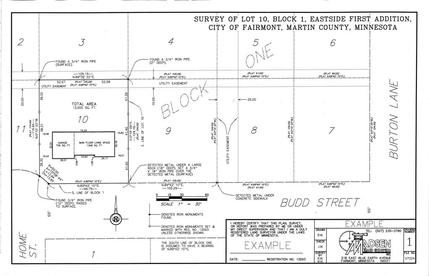
Lot Surveys
Lot surveys are surveys conducted to find and or determine existing lines of lots and blocks within platted (in most cases) areas of lands. Lot surveys can also subdivide larger lots into smaller lots, and rearrange existing lines.
Lot surveys are generally required before improvements are made to a property such as a fence or structure located near a property line. In the cases of home construction or additions, lot surveys can delineate building setback lines and area requirements to satisfy zoning regulations and other codes which may have an impact on the extent to which the property may be improved.
Farm Surveys
The term "farm survey" can actually have more than one meaning, depending on the circumstances of the particular job. Most often, farm surveys are used to locate or determine existing boundaries of land or are used to legally separate building sites from the rest of the land.
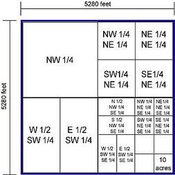
Section Subdivisions
Most lands that are located outside the city jurisdictions or lie within areas of land are called sections. Sections are nominally 1 square mile tracts of land which have usually been broken down or subdivided into smaller tracts or aliquot parts (ex: SE 1/4, or W 1/2, NE 1/4, and so on).
One of the most common uses of the farm survey is to locate the existing boundaries and determine the area of land which has been subdivided in this manner. In other cases, this type of survey is used to divide larger portions of sections into smaller ones. In both cases, it is common that the survey will require the finding or re-establishment of several, if not all of the section and quarter-section corners in that particular section, in order to properly determine and or further subdivide the areas of land in question.
Building Site Surveys
Building site surveys are a type of farm survey where there is an existing area of land that is not an aliquot part and needs to be legally separated from its parent tract for one reason or another. It could be that new construction is planned, or that there is already a building site there, but whatever the reason, the scope of this type of survey is to divide a section or part of a section into two or more smaller tracts, one being the new "building site" tract, and the other being the remainder.
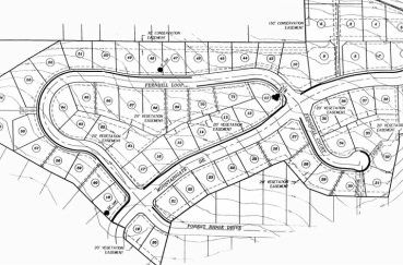
Subdivision Platting
Subdivision platting is the process by which a large area of land is divided into several smaller areas called lots and blocks. In addition to lots and blocks, part of the land is also usually dedicated to the governing body as a public right of way (usually streets and alleys).
Subdivision platting is a relatively lengthy process and generally begins with a boundary survey of the tract of land which is to be divided and platted. After the boundary survey is completed, a topographic survey usually follows, in order to determine the relief of the land and to show other features that will be important during the planning phase.
Once the boundaries have been determined and the relief and other features have been identified, the planning process begins. The planning process is when the size, shape, and number of the lots are determined, and the initially proposed layouts are submitted to various governing entities (county commissioners, city councils, etc.) for approval.
Upon approval of the preliminary plat, the final designed layout is staked in the field, and the official plat is drawn. Once all of the interested parties have signed the plat, and the finalized version has been approved, the plat is recorded and goes into effect.
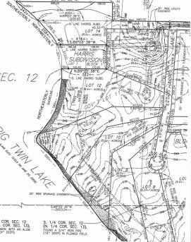
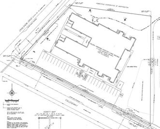
Topographic Surveys
Topographic surveys are surveys intended primarily to show the relief or change in elevation of an area of land. Topographic surveys also usually show other planimetric features, such as buildings, paved surfaces, located utilities, and distinct changes in the surface of the land.
Topographic surveys are commonly used in the early stages of planning for major property improvements, or for changes in the landscape that may impact drainage or water flow. Topographic surveys can also be used to calculate volumes of the earth in advance or following significant earthwork.
ALTA Surveys
ALTA Land Title Surveys are surveys conducted usually prior to the issuance of a title insurance policy, which are sometimes required by lenders when dealing with commercial properties of significant value.
ALTA Surveys can sometimes be among the most extensive and comprehensive types of surveys there are. The primary purpose of the ALTA survey is to reveal any potential survey or boundary-related issues that could possibly affect the title of a piece of property, prior to the issuance of the title policy. There are uniform accuracy and detail standards put forth by the ALTA (American Land Title Association), which are meant to ensure a uniform, quality product in all cases.
In addition to these requirements, ALTA surveys also often include additional, optional detail requirements such as the depiction of contour lines, locating easements and encroachments, locating buildings and other improvements, and the locating of underground and above ground utilities.
Share On: